Meta Quest 3 · General Aviation · Mixed Reality
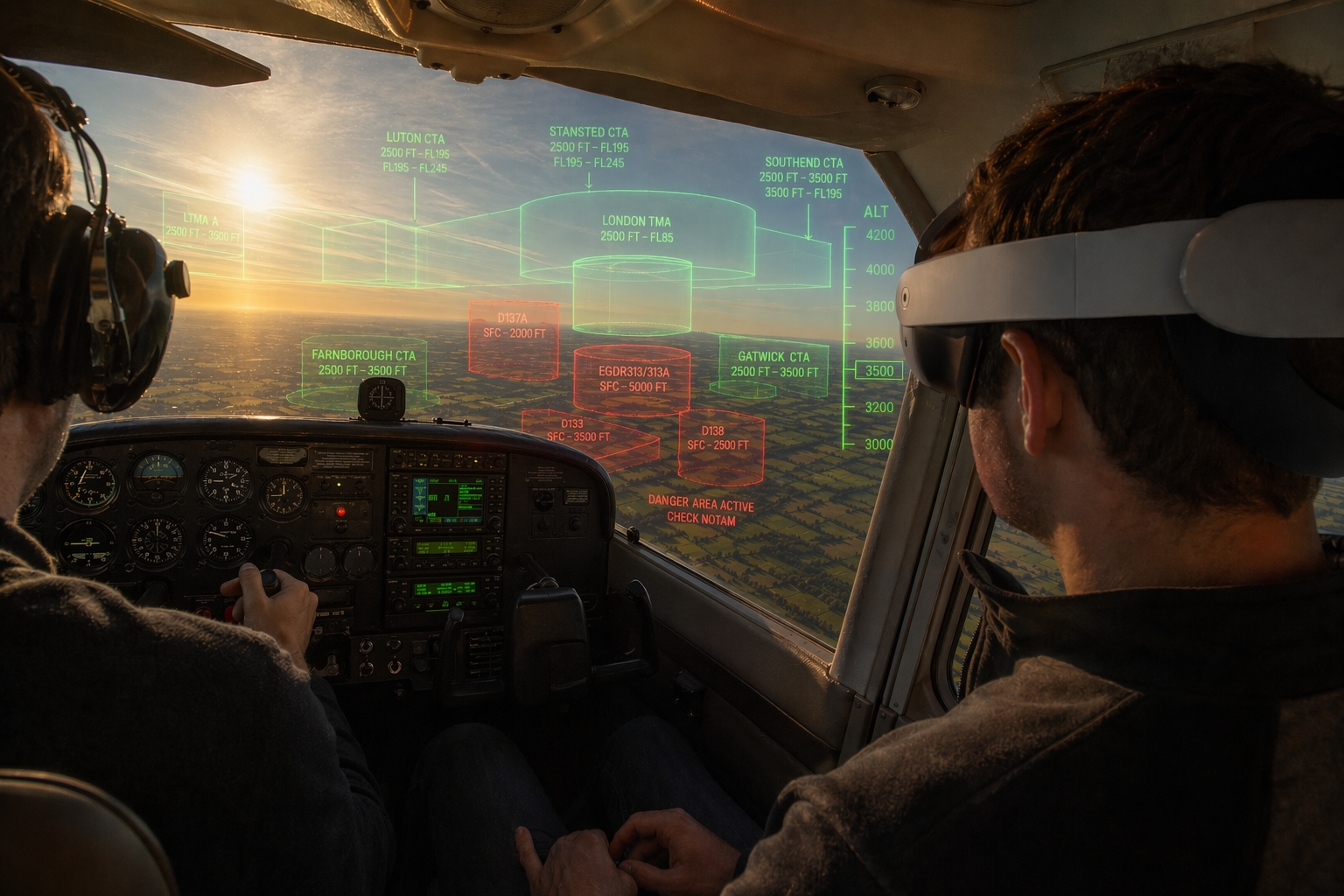
Your Airspace.
Now Visible.

SkyWatch renders nearby aircraft and airspace boundaries directly in your field of view — real-time, color-coded, and always oriented to your position. Supplemental situational awareness, reimagined in mixed reality.

20 nm Traffic Radius
Live ADS-B Traffic
3D Mixed Reality
Pilot wearing mixed-reality headset in a GA cockpit with airspace boundaries and traffic overlaid in the field of view

Traffic awareness that
goes where you look.

SkyWatch is a portable supplemental traffic and airspace awareness display for general aviation pilots. Running on Meta Quest 3, it overlays nearby aircraft as 3D markers in your real-world field of view — positioned correctly by bearing, distance, and altitude relative to your aircraft.

No panel modification. No installation. Strap on the headset, and your airspace comes alive around you.

  • Real-time aircraft data from live ADS-B sources
  • Color-coded threat assessment at a glance
  • 3D airspace explorer with real controlled airspace boundaries
  • No panel space, no hardwiring, no certification burden
OWNSHIP TRACKING
Position29.990 N 95.337 W
Altitude4,500 ft MSL
Ground Speed118 kt
Track270°
TRAFFIC · 4 TARGETS 1 ADVISORY
N12345 +800 ft · 4.2 nm · 124 kt
N67890 -400 ft · 6.1 nm · 098 kt
UAL442 +2200 ft · 11.7 nm · 430 kt
DAL918 +5100 ft · 18.3 nm · 460 kt

Everything you need to see the picture.

Built for the realities of a GA cockpit — quick to put on, easy to read, and designed around the way pilots actually scan for traffic.

Bearings-First Display

Aircraft markers are positioned in true 3D space relative to your ownship — correct bearing, range, and vertical separation rendered directly in mixed reality. Look toward traffic to see it.

Threat-Coded Colors

Green, amber, and red markers instantly communicate threat level — configurable thresholds based on range, altitude separation, convergence rate, and data freshness.

Rich Target Labels

Each aircraft shows callsign, altitude, relative altitude, distance, ground speed, heading, and route info. Point your controller to expand the full 6-line detail panel.

3D Airspace Explorer

Use Quest controllers to fly freely through a compressed 3D replica of your airspace. Climb above the traffic layer, orbit targets, and understand the full picture spatially.

Live Terrain Map

A real-time 3D terrain and satellite imagery layer keeps you oriented geographically while traffic markers float at their correct altitudes above the landscape.

Compass Overlay

A persistent heading readout keeps you oriented at all times. The 20 nm visibility ring gives you an instant sense of your traffic radius in the mixed-reality scene.

Route Display

"LHR LONDON → JFK NEW YORK" — SkyWatch queries route data for identified aircraft, so you immediately know where traffic is going and why it's crossing your path.

Controller Point & Inspect

A dual-layer glowing laser pointer extends from your right controller. Aim at any aircraft or airspace wall to lock on — the full detail panel opens in place, showing everything from callsign and route to airspace class and altitude limits. Point away to dismiss.

3D Airspace Boundaries

Real controlled airspace rendered as semi-transparent 3D walls — CTRs, TMAs, ATZs, danger areas, and restricted zones all visible around you. Color-coded by ICAO class (A through E) so you can see exactly where controlled airspace begins and ends, and at what altitudes. Tap any wall with the laser to see full details.

Altitude Tape

A PFD-style vertical altitude indicator sits on the right side of your field of view — scrolling smoothly as you move, with tick marks, scale labels, and a boxed current-altitude readout. Just like a real primary flight display.

C

Current Airspace HUD

A permanent readout below the compass shows which airspace you're currently inside — class, name, and altitude limits. Displays "Class G" when you're in uncontrolled airspace. Always visible, always accurate to your position.

Passthrough Mode

Toggle between a virtual 3D environment and real-world passthrough with one button. In passthrough mode, you see your actual cockpit and sky — with traffic markers and airspace boundaries overlaid on top. No visual isolation from the real world.

North Lock

Align to north once at startup and SkyWatch holds it — even if you remove the headset mid-flight and put it back on. Every aircraft bearing stays true to the real world without recalibration.

From headset to airspace in seconds.

No configuration hassle. SkyWatch is designed to be ready when you are.

01

Put on the Quest 3

SkyWatch runs in passthrough mode — you see the real cockpit and sky around you, with traffic overlaid on top. No visual isolation.

02

Connect to WiFi

SkyWatch connects to live ADS-B traffic data sources over WiFi, pulling real aircraft positions within a 20 nautical mile radius of your location.

03

Aircraft Appear Around You

Nearby aircraft are rendered as 3D markers at their correct bearing and relative altitude. Each target updates every 15 seconds — color-coded by threat level.

04

Point to Inspect

Aim your controller at any marker to see the full detail panel — callsign, altitude, vertical rate, speed, route, and more. Everything you need to build your mental model.

Live data. Multiple sources.

SkyWatch supports multiple traffic data sources — live ADS-B feeds, portable receivers, companion apps, or offline scenarios.

Live

Live ADS-B Network

Connect to global ADS-B traffic networks over WiFi for real-time aircraft positions, altitudes, and ground speeds around you.

Real-time traffic 20 nm radius
Coming

Stratux / GDL90

Connect to a Stratux ADS-B receiver over WiFi for cockpit-sourced traffic data — independent of internet connectivity.

ADS-B In hardware No internet needed
Coming

GPS Companion App

Stream your live GPS position from a companion phone app over WiFi — giving SkyWatch precise ownship data for accurate marker placement.

Phone or tablet Live GPS
Offline

Offline Demo Mode

Built-in traffic scenarios available with no connectivity — great for familiarization, demos, and pre-flight review.

No connectivity 8 target scenarios

Every detail, at a glance.

Each traffic marker shows a rich set of information — without cluttering the view. Point your controller to see the full panel.

N12345
4500 ft ↑+800 ft
↑ +200 fpm
4.2 nm · 124 kt · 090°
KIAH HOUSTON → KDFW DALLAS
SQK 1200 · United States · A12B3C
Callsign / Flight ID
Altitude (MSL) + Relative Altitude
Vertical Rate
Distance · Speed · Heading
Route (departure → destination)
Squawk · Country · ICAO Hex

Safety Disclosure

SkyWatch is a non-certified, supplemental advisory tool. It is not a substitute for see-and-avoid vigilance, ATC traffic advisories, certified traffic alerting systems (TCAS, TAS, ADS-B In), or any required installed equipment. It does not meet certification standards under FAA, EASA, or any equivalent authority.

SkyWatch provides supplemental situational awareness only. The pilot in command retains full responsibility for traffic separation and safe flight operations at all times. Do not rely on SkyWatch for collision avoidance.

Early Access · Pilots & Enthusiasts

Be first in the pattern.

SkyWatch is in active development. Join the waitlist to get early access, provide feedback, and help shape a product built by pilots, for pilots.

No spam. No commitment. Unsubscribe any time.